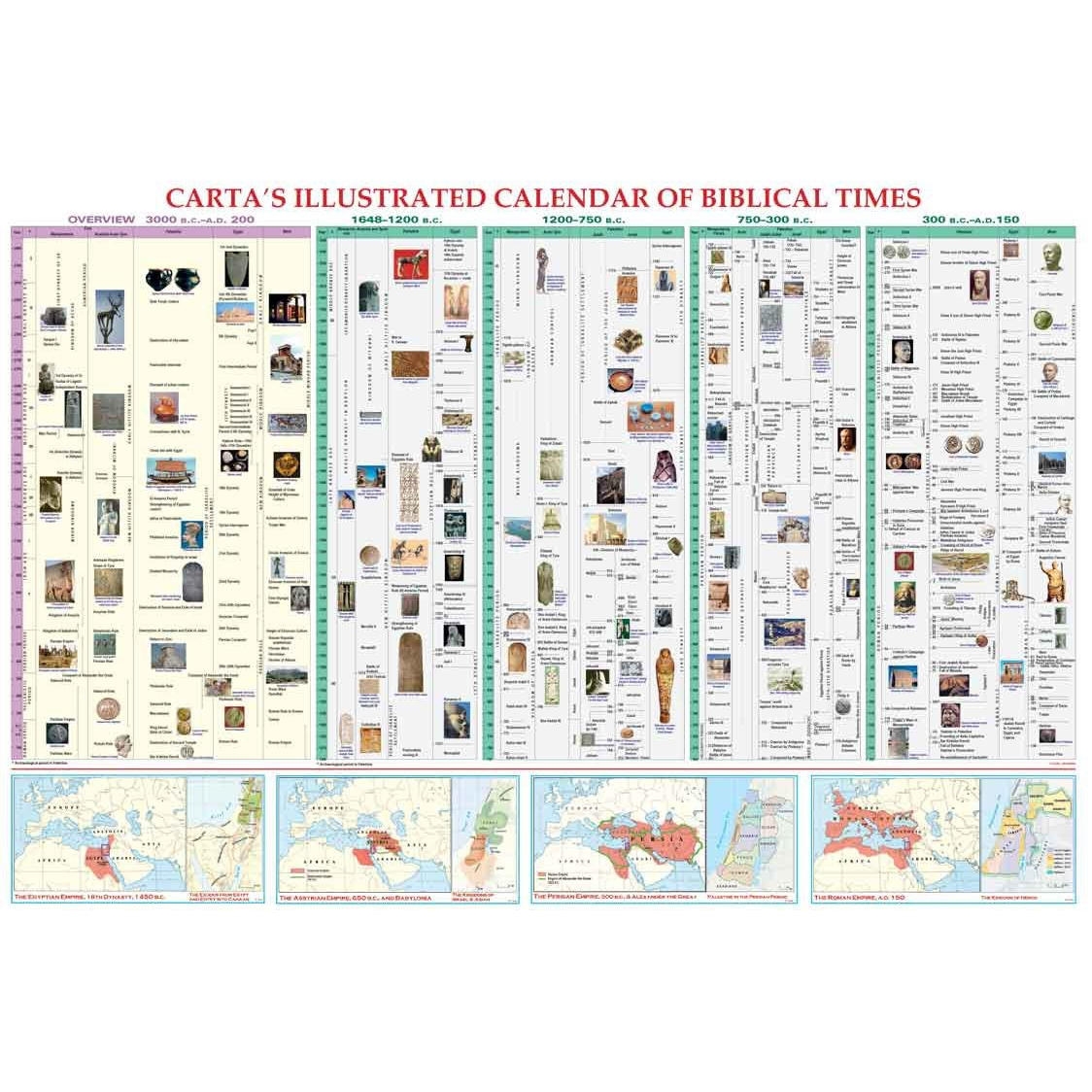
“The Most Detailed Chronology of Biblical Times Ever.” Compiled by eminent scholars of biblical history, this chart provides a comparative view of parallel cultures in the time of the Bible. Enhanced by contemporary artifacts and images, the time line gives both a general overview (from c. 3000 B.C. to A.D. 200) of the major historical events in the Ancient Near East, Palestine, Egypt and the West, and a detailed section, beginning from c. 1650 B.C., that highlights the biblical period and its rulers, kings, and prophets. Also features comparative maps of the Holy Land within the empires of Egypt, Assyria, Persia, and Rome.
* Specially designed as a teacher’s aid for use in the classroom. * Suitable for adults and children alike.
70 x 100 cm (28 x 40 in.); full color; maps; illustrations; laminated
Otherwise, please select your country below so we can display the correct prices, delivery times and delivery costs for your location.
product
https://www.judaicawebstore.com/-cartas-illustrated-calendar-of-biblical-times-p140084295 Carta's Illustrated Calendar of Biblical Timeshttps://www.judaicawebstore.com/media/catalog/product/c/r/cr-0084.jpg19.9519.95USDOutOfStock/Judaica/Jewish Books/Israeli & Jewish History/Jewish Gifts from Israel/Biblical Gifts35886271 <P><BR>“The Most Detailed Chronology of Biblical Times Ever.” Compiled by eminent scholars of biblical history, this chart provides a comparative view of parallel cultures in the time of the Bible. Enhanced by contemporary artifacts and images, the time line gives both a general overview (from c. 3000 B.C. to A.D. 200) of the major historical events in the Ancient Near East, Palestine, Egypt and the West, and a detailed section, beginning from c. 1650 B.C., that highlights the biblical period and its rulers, kings, and prophets. Also features comparative maps of the Holy Land within the empires of Egypt, Assyria, Persia, and Rome.<BR></P>
<P>* Specially designed as a teacher’s aid for use in the classroom.<BR>* Suitable for adults and children alike. </P>
<P><STRONG>70 x 100 cm (28 x 40 in.); full color; maps; illustrations; laminated </STRONG></P>
00add-to-cartCarta